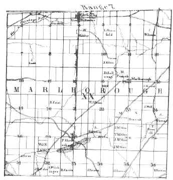
 In the Fall of 1805, Abraham Wileman and his son, Mahlon, traveled from Columbiana County to build a log cabin in section one of what is now Marlboro Township. When the cabin was completed, Mr. Wileman returned to his home, leaving Mahlon to spend the winter alone. He lived a difficult life as the township's first permanent settler. The following spring his father brought the rest of the family to the area, and they started another farm in section 23. (The map, which shows the locations of their land, is from one drawn of Stark County in 1840.)
The land in Marlboro Township was included as a part of Lexington Township when the latter was organized in 1816. In 1821, the Stark County Commissioners divided the large area and created two separate townships, Lexington and Marlborough (later spelled Marlboro).
In 1827, William and Moses Pennock, Samuel Ellison, and Dewey Johnson had land they owned surveyed and had a plat drawn. (A plat is a diagram of the lots and streets.) The plat was then recorded as the town of Marlborough in the books at the Court House in Canton.
New Baltimore, developed on land first owned by Levi Haines, became the township's second village in 1831. A log tavern was constructed which later was an important stagecoach stop. The frame building which replaced it is still standing on the southeast corner of the square and is now being restored.
When it was first seen by the early pioneers, about one fourth of Marlboro Township was under water. Drainage systems were developed to make more land tillable, but even in the 1880's, the vast peat beds were considered useless. Around the turn of the century Mr. F. P. Keener looked at the western swamps and decided that celery could be made to grow there. To him is given the credit for beginning the area's famous vegetable industry.